Friday, November 27, 2009

Lake Bonney Part2: ENDURANCE

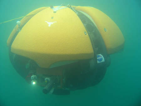
One of the other research projects being conducted on Lake Bonney (UNDER Lake Bonney, really) is called: ENDURANCE :

The Environmentally Non-Disturbing Under-ice Robotic Antarctic Explorer (ENDURANCE) robot probe is scheduled for some tough tests in the next few weeks. The goal is to help NASA explore the underwater environment of Europa, one of Jupiter's moons.


We were fortunate to meet up with this team as ENDURANCE was traveling UNDER Taylor Glacier to provide the FIRST EVER! images under a GLACIER -- watch for the NEWS STORY to come out shortly......

Monday, November 23, 2009

Lake Bonney

Over the Glacier from Lake Hoare, sits Lake Bonney ....

and the remainder of our streams: Lawson, Priscu (named after researcher John Priscu), Lyons and Santa Fe. We will also visit Blood Falls (more on this later)....

We will have now visited our entire complement of Streams for the first time .....and will begin our rotation visiting each stream one time/week to collect water flow measurements and collect samples....

Below is our map of Taylor Valley -- consisting of Lake Fyrxell, Lake Bonney, and Lake Hoare -- can you find them? The red markers are the stream sites at each of the Lakes......

The Stream sites are named according to the Lake they drain. For example, F1 = Canada Stream. It is the first stream on Fyrxell and flows out of Canada Glacier. Our sites are named: F1, F2, F3, F4 ....F10; H1, H2; B1-B4 -- can you figure out which stream goes with which number??? (Test will come later...)

Here is the "team" ready to work:
HAPPY THANKSGIVING!

Sunday, November 22, 2009

Wright Valley

The helicopter drops us off in the Wright Valley ....

to open gaging on the Onyx RIVER!

The Onyx is the only official USGS RIVER in Antarctica (it has been said that the Kiwis RAFTED on this river!)

We arrived before the water is flowing in time to survey the location:

(Seth surveying)


And exchange the N2 tank and retrieve last year's data.


Here is what we can expect to come.......


"How does Wright Valley differ from Taylor Valley?"

The Wright Valley is different from Taylor Valley in the lack of snow, warm lake temperatures, unusual rock features, desiccated seal carcasses, and an almost complete lack of plant life.

Large differences in salinity and ionic composition of the lakes are related,in part, to how the lakes have responded to climatic changes through the Holocene. Chemical variations among streams are due, in part, to their geomorphological differences, the amount of water–rock interactions within their hyporheic zones, and the amount and composition of dust and soil blown onto the glacier surfaces.


Do you notice the differences in this picture?

While the streams in Taylor Valley drain to Lake Fyrxell; Onyx River drains to Lake Vanda in the Wright Valley.


Next stop, set of gages on Lake Bonney......

Friday, November 20, 2009

Science Friday - SCINI!


What is SCINI?

SCINI stands for Submersible Capable of under Ice Navigation and Imaging. She is an underwater robot specifically built to complete science missions beneath the frozen surface of the ocean in Antarctica.


The remotely operated vehicle SCINI cruises over the seafloor
under the ice in McMurdo Sound, Antarctica.

SCINI is a remotely operated vehicle (ROV) which means that a tether to the surface allows the pilot to see what she sees through her camera “eyes” and control where she “swims” with her five thrusters.


A test mission at MBARI in Monterey Bay, California. You can see the lighted camera dome on the left, and thrusters to move SCINI up/down, left/right, and forward/back arrayed down her body.

The pilot uses a joystick that looks suspiciously like a video game controller (because it is one) and views the world on a computer flat screen that shows not only the seafloor around SCINI but also the vehicle status array and engineering diagnostics.


The central screen is the views from the cameras, the screen on the left is the engineering screen, and the screen on the right is the navigation screen.

SCINI finds her way around in the ocean using an integrated South Star navigation system that has been developed in partnership with Desert Star Systems. This wireless array allows us to extend the accuracy of GPS beneath the water where satellite signals cannot penetrate. And, what is SCINI finding her way towards? That is what the scientists decide, and this year SCINI will be diving deeper and in more remote locations, in order to describe Antarctic seafloor communities that have never before been seen by human eyes.


SCINI found this unidentified octocoral species at 190 m depth under the McMurdo Ice Shelf.

For more information on the SCINI project visit: http://scini2009.mlml.calstate.edu

Thursday, November 19, 2009

Wright Valley --stand by

Our trip to the Wright Valley (via Helicopter)........
delayed due to Katabatic wind

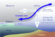
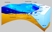
Sketch of the generation of Katabatic Winds
A katabatic wind, from the Greek word katabatikos meaning "going downhill", is the technical name for a drainage wind, a wind that carries high density air from a higher elevation down a slope under the force of gravity. Such winds are sometimes also called fall winds.

Katabatic wind in Antarctica

Katabatic winds are most commonly found blowing out from the large and elevated ice sheets of Antarctica and Greenland. The buildup of high density cold air over the ice sheets and the elevation of the ice sheets brings into play enormous gravitational energy, propelling the winds well over hurricane force.[1] In Greenland these winds are called Piteraq and are most intense whenever a low pressure area approaches the coast.

Helos will be cleared and we will be off....

Map of Wright Valley, Antarctica


List of streamgages shown on the map:
Site number Stream
14 Onyx River at Lake Vanda Weir
15 Onyx River at Lower Wright Weir

So, what makes the streams and valleys different from one another......

Stay tuned.......and we will see you in the Wright Valley!

Wednesday, November 18, 2009

Streams in Taylor Valley

We have been spending the last days preparing to gage the following streams:

Map of Taylor Valley

List of streamgages shown on the map:

Site Number Stream
1 Canada Stream
2 Huey Creek
3 Lost Seal Stream
4 Aiken Creek
5 Von Guerard Stream
6 Crescent Stream
7 Delta Stream
8 Green Creek
9 Andersen Creek
10 House Stream
11 Priscu Stream
12 Santa Fe Stream
13 Commonwealth Stream
16 Lawson Creek
17 Harnish Creek
19 Lyons Creek
20 Harnish Creek Tributary

Can you find them all on the map?

According to the USGS, Stream-gaging consists of the following Streamflow Data:

1. Stage - which is the height of the water surface above a reference elevation.

2. Discharge - the measurement of cross-sectional area and the velocity of the flowing water.

• We use a pgymy meter to measure the velocity of the water. A Pgymy meter consists of a spinning set of 'cups' that rotate in the water and spin around to measure the water speed.

Other measurements we make at the streams are for water quality:

pH, Anions, Cations, Nutrients and Dissolved O2. We are interested in the amount and type of ions (ie Ca2+, K+,Na+, Cl-, HCO3-,SO3-)


Find the elements that form these ions on the Periodic Table:


We are off to the Wright Valley to gage the streams there........

Monday, November 16, 2009

Home Base .....Part 2: We Have Arrived!

Our scheduled Helo drop was turned into a hike over the Glacier -- and it was well worth it!

Our day started out ominous.....


But once we rounded Canada Glacier - the skies cleared.....


And we had a glorious day...


And we arrived home.....Lake Fyrxell (F6)

And the work began.......I chopped the lake ice to melt for drinking water....


Chopping ice and 'picking glacier berries' will be our supply of water for drinking and cooking. No other place on the planet can you drink straight from the Glacier!

We are off to open Stream Gauges:
F1 (Canada Stream)
F2 (Huey)
F3(Lost Seal)
F4(McKnight)
F5 (Aiken)
F6 (Von Guerard)
F7(Harnish)
F8(Crescent)
and F10(Delta)......

More on Stream Gauging, Water Sampling and Surveying to come......

Sunday, November 15, 2009

Delayed Due to Snow!


Around 98% of Antarctica is covered with ice. The Dry Valleys region is the largest area on the continent NOT covered by ice.

Located in the mountains by McMurdo Sound, on the part closest to New Zealand, the Valleys receive the equivalent of 10cm of water per year in the form of snow.

However, this year, we will most likely surpass that average .......our departure to Lake Fyrxell and F6 was delayed due to SNOW!


This delay gave us time to catch up on email, do some research and REST UP for the next day's adventure! Stay tuned for our journey to Lake Fyrxell .........

In the meantime, here are some Facts On the Dry Valleys.........
  • There are (3) Large Valleys that make up the Dry Valleys:


Taylor,

Wright,

and Victoria


  • The Valleys are about 80-100km long, 8-10km wide and 3km deep.
For comparison, how far is it from Boulder to Ft. Collins?


  • The Surface of the valleys include: gravel floors with large expanses of bedrock. The bedrock consists of Precambrian metamorphic rock of the Koettliz Group (OK -- now you have some HOMEWORK!)

  • It is thought that the valley landscape is due to glacial erosion.
Next..... A WORD ON GLACIERS
  • Glaciers of the McMurdo Dry Valleys are fundamental to the hydrology and biology of the Dry Valleys because they are the only significant source of water.
  • Understanding the glacial events and meltwater runoff is the key to understanding the Dry Valley ecosystem.
  • Of all forms of mass loss, sublimation accounts for 70% of total glacial mass loss. What is sublimation?
  • The Dry Valley Glaciers are classified as polar glaciers. Polar Glaciers mean their interior and basal temperature are well below freezing and the glacier is frozen to the ground underneath (thus the glacier is not advancing much).

[Glacier_-_Antarctica.JPG]
  • The climate of the Dry Valleys is that of a cold desert. Average air temperature is -20C and the warmest summer months (Oct-Feb) 1.4C.
  • Solar radiation is the important driving force for the hydrological and biological systems in the Dry Valleys. It influences sublimation, heating of the soils and air, and providing energy for photosynthesis by the microbial communities.
  • Solar radiation levels were 84-117 W/m2 in 1994. In 2007, the average was 208 W/m2.
What would be some possible outcomes of increased solar radiation?


Thursday, November 12, 2009

Next Field Camp .... F6 (Our Home Base)

We are on the move again.....


Due to the storm (fierce winds) the helicopters are not flying so we will be HIKING OVER CANADA GLACIER to our next field camp (F6) on Lake Fryxell.

DID YOU KNOW: Glaciers currently cover about 10% of the world’s land area and contain 75% of the world’s freshwater. Although they are most prevalent in polar regions like Antarctica and Greenland, they can be found on nearly every continent.

F6 on Lake Fyrxell will serve as our HOME BASE for most of our time in the Dry Valleys (with Lake Hoare our 'weekend' home). Most of our testing supplies have been dropped here so we will gather up all of our supplies, set up camp and open our 'temporary lab' to run our water samples.

We will visit: 3 of our stream sites today---including LOST SEAL.


For the story of the Lost Seal, check out: http://www.mcmlter.org/lostseal/ You can also check out the book from the Boulder Public Library!

Science Friday - PENGUINS!

Did you know that there are SEVENTEEN species of penguins?
Of the 17 species of penguins, only four breed on the Antarctic continent itself: the Adelie, the Emperor, the Chinstrap and the Gentoo penguins. Most other species are found within the subantarctic regions which includes many coastal islands. Penguins are also found as far north as the Galapagos Islands, straddling the Equator.

Jean Pennycook has been tracking the Adelie penguins on Cape Royds for 8 seasons.....you can see her penguins LIVE on PENGUIN CAM: http://thistle.org/pcam/

Feature Penguin:
Adelie

Adelie Penguin

Population:
2.5 million pairs
Location:
Antarctic region
Size:
About 30 inches tall
Weight:
11 pounds
Diet:
Fish, krill, & other small crustaceans
Nests:
Circle mounds of small stones


Also check out the great PENGUIN fun at: www.penguinscience.com/classroom_home.php

Penguins Marching into Your Classroom


We wanted to know how climate change is affecting the penguins. We traveled with Dr. David Ainley, on of the most respected penguin researchers in the world. And this is our story.........


Penguins Helped and Hurt by Changing Climate


We take off by helicopter from America's main research base in Antarctica (McMurdo Station) toward Cape Royds, where exactly 101 years ago, in 1908, scientists started studying the local penguin colony. It takes only 20 minutes to get there, but it's one of the most spectacular trips of my life. The Earth is blinding white in every direction. We pass a white wall of mountains off to the left (Dry Valleys) and, on the right, an active volcano with steam curling out of the vent (Mt. Erebus).

Then the helicopter drops us in a small clearing. We climb a snowy ridge, and there at the top are thousands of noisy penguins. They're crowded together on a mound of black volcanic rock, and they're squawking and cooing their hearts out.

These penguins are called Adelies. They look like emperors, which were showcased in the hit movie March of the Penguins. Only Adelies aren't as big — they barely come up to my thighs. Most are milling around; some are flopped on their stomachs on nests which they make out of stones. There are fuzzy chicks that look like toys.

Our guide is Dr. David Ainley. He says he loves studying Adelie penguins, partly because they're so out there. Literally.

"There's no bushes here; they don't dig burrows. They just sit out here in full view and they don't really care if we're around. They have no secrets," Ainley says.

It's surprising to hear him talk this way, because researchers don't usually ascribe human emotions to animals. But when Ainley talks about these penguins, it sounds like he's talking about friends.

"Penguins have no self-doubt," Ainley says, adding sheepishly: "Which I have lots of, for myself. "They are good examples of how we all should live. They're the epitome of the word dauntless," Ainley says.

These Adelies dive up to 400 feet, dodging giant ice floes the size of cars which bash around in the surf. Some of the penguins are already coming back, shooting straight out of the water like a circus trick. Ainley says they can leap nine or ten feet, popping out of the water like corks.

Finding Answers

Scientists say penguins are providing some of the first clues of how global warming is changing the planet. And Ainley has come up with evidence by asking very basic questions: Is this penguin colony growing or shrinking? Are the penguins finding plenty of fish to eat or are they hungry? To get the answers, Ainley arms himself with a syringe loaded with tiny computer identification chips. Then he and his colleagues grab a penguin and hoist it like a squirming dog.

"We put them under our arm and hold them tightly. They're extremely strong. They're very aggressive, and they're very territorial," Ainley says. "And they definitely aren't used to being touched ... They don't even want to be touched by another penguin."

Still, the researchers inject a chip in every angry penguin's shoulder. Then they take a computerized scale, which looks like a rubber mat, and they place it on the path so the penguins cross it. This system lets Ainley track all kinds of information. For instance, what time does each penguin go fishing and when does it come back? How much weight does the penguin gain or lose?

An Unpredictable Future

Scientists have been doing similar studies in other parts of Antarctica. They've plotted their findings against the climate. The results are striking. During the past few decades, as climate patterns in some parts of the continent have changed dramatically, Adelies in some regions have almost disappeared. Their numbers have plunged 80 percent. But the Adelies where Ainley does his research are doing better than ever.

"These penguins are definitely being helped by climate change," Ainley says.

Ainley and other researchers think they know why. Most types of penguins go fishing only in open water, so they're all competing with each other to find food. But Adelies catch their fish by diving deep under the ice. In fact, they're just about the only penguin that can physically do that. So, when there's plenty of ice over the sea, Adelies hardly have any competition and they can get all the food they want.

Now the changing climate is shaking things up. In some areas where most of the ice has melted, Adelies can't survive. But Cape Royds used to have too much ice, and now it has just the right amount. So penguins here are doing great.

Ainley says here's the moral: Global warming is making life unpredictable. Early this year, he was studying another penguin colony, and a glacier was melting.

"There were huge rivers running off this glacier, running through the penguin colony, and the rivers were engulfing these penguin nests. And the penguins just kept collecting rocks to try to make their nests bigger, raise them up out of the water. And for many of them, they couldn't collect rocks fast enough. And so their eggs were just washed away," Ainley says.

Ainley's radio crackles, and we get word that our helicopter is arriving soon....

For more information on Dr. Ainley and his research:


http://www.penguinscience.com/current_sum.php


For More Penguin Stories and Penguin facts visit: www.penguinscience.com/classroom_home.php - or -

http://kids.nationalgeographic.com/Animals/CreatureFeature/Adelie-penguin


Keep Marching Penguins........